Identity area
Reference code
PDM-02-50000
Title
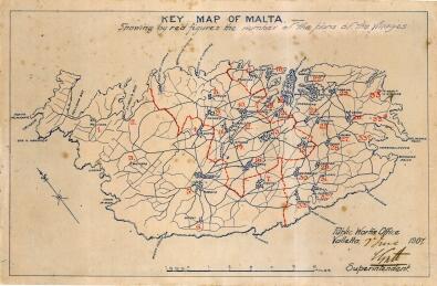
Key Map of Malta - Showing by Red Figures the Number of the Plans of the Villages
Date(s)
- 1907 (Creation)
Level of description
Item
Extent and medium
One Map size:250 x 360 in Paper (Heavy)
Context area
Name of creator
Biographical history
Archival history
-
Immediate source of acquisition or transfer
Content and structure area
Scope and content
Site: Villages in Malta and Gozo 1907- by Architect: N/A
Appraisal, destruction and scheduling
Accruals
System of arrangement
Conditions of access and use area
Conditions governing access
Conditions governing reproduction
Language of material
Script of material
Language and script notes
Physical characteristics and technical requirements
Physical Condition: Good; Staining: FALSE; Creasing or wrinkling: FALSE; Torn edges / corners: FALSE; Torn through center of drawing: FALSE
Finding aids
Allied materials area
Existence and location of originals
Drawer 6
Existence and location of copies
Related units of description
Notes area
Note
Dated 7/6/1907; Key map with numbers corresponding to each drawing within the collection Villages in Malta and Gozo 1907
Alternative identifier(s)
Access points
Subject access points
Place access points
Name access points
Genre access points
Description control area
Description identifier
Institution identifier
Rules and/or conventions used
Status
Level of detail
Dates of creation revision deletion
Language(s)
Script(s)
Sources
Digital object metadata
Latitude
Longitude
Media type
Image
Mime-type
image/jpeg
Filesize
102 KiB
Uploaded
July 24, 2020 7:19 AM